Saturday, October 26, 2013

Monticello and the Natural Bridge

Thomas Jefferson has long been one of my heroes. He wasn't a perfect man, but he was awesome for his time.
Here I am with TJ. He is tall. And he is aloof.


We had stopped in Byoona Vista, as I mentioned earlier, to visit our old friends Etta and John. We drove down to Monticello on Tuesday morning. Luckily, the house is owned by the Thomas Jefferson Foundation (a mighty good concept, if you ask me) and not the Federal Government, as the government shut-down that morning prevented us from visiting Appomattox.

Here we are. I think I am telling the volunteer how to work the camera.


 I was kind of "ho hum" about the whole thing, although I didn't let on, because old houses are only so thrilling, in my book. As it turned out, it was a fascinating look into the brain of old TJ. 

Take, for instance, the entrance to the home. Note the compass in the ceiling and the great clock on the wall, which was designed by TJ. It has two faces, one facing the fields outside, thus serving the field workers as well as the inhabitants of the house. It struck a gong on the hour and doesn't have minute hands. Each section between the numbers is divided into quarters and then into five-minute increments. 

The hall served as a reception room and waiting room for visitors, as well as a museum of American natural history, western civilization, and American Indian cultures.


The house is full of Jefferson's innovations, but photos are not allowed. I did, however, sneak this one of the kitchen, because I do love a well-stocked kitchen.


Houses were not commonly built so high up on a hill in Jefferson's time, but he loved the view and figured out a way to do it. You can understand why he craved the peace and beauty of this view.


There is a dig in progress in the slave quarters. It looked like a fun job on this sunny afternoon.


We walked along the gardens on the way back to the bus and I was quite taken with these snake-like squash.
And I may or may not have filched a few corn seeds along the way.


The front of the house, which looks almost identical to the back.


I could go on for hours about Jefferson and all of his cleverness in the house and the gardens, but I am feeling lazy, so you will have to visit there yourself. 

We couldn't resist a photo in the magnificent linden tree at the entrance to Monticello. I believe this was a young tree in Jefferson's time.


We stopped off at the graveyard on the way down to the visitors' center. A couple of gravestones caught my eye.
I want this on our stone when we die.


And this one made me a little sad.


We stopped at Michie Tavern for some lunch/dinner. It was very delicious and strangely served as a buffet for the first helping, but then you had to tell a waiter when you wanted seconds of anything and they were supposed to bring it to you. Not very satisfactory, because you can see what happened when I asked the waiter for some more cornbread, specifying that I wanted a middle piece, not the ends.


I tried to hail him to see why he brought me some dried-out old ends, when we saw him out of the window, high-tailing it down a path towards the shops. I had to find someone else to get me some more cornbread, and she was a bit indignant and defensive of the original waiter. When he came back, he toddled over to our table and apologized, saying that he thought I asked for the ends, and then giving us a sad story about having to buy some new shirts for his job and how expensive they were.
Um, don't want to hear, closing my ears now!

We drove back to Byoona Vista and said our farewell to John and Etta, and headed for the Natural Bridge, which was high on my list of priorities to visit. 
We arrived at five o'clock, only to find that the attractions were closed and the only thing we could visit was the bridge. We were okay with that, so here we are.


In 1774, Jefferson bought 157 acres (including the natural bridge) from King George of England for twenty shillings. I heard somewhere that it equals about $1,200 in today's currency. Quite a steal. But if you think about it, he probably should have waited a couple more years and it would have been his for nothing!
The bridge is massive, but you don't get much of a feel for it until the next photo.


There is teeny-tiny Jeff, standing at the bottom.


Light was fading fast, but I wanted to stay until seven o'clock to see the Drama of Creation, a light show with music and the biblical account of the creation that was inaugurated by Calvin Coolidge in 1927. After all, I said to Jeff, it's unlikely that we will ever get back this way again.
To pass the time, we walked along the Cedar Creek Trail to Lace Falls in the rapidly waning light.
The base of the creek is unusual, consisting of rippled and layered stone.


Lace Falls.
We were underwhelmed.


We arrived back at the seating area just before it got too dark to see, and still had half-an-hour to wait. The show was quite spectacular (have I been using that word a lot lately?) and I am glad we waited to see it. The half-hour show consists of narration, accompanied by a light show and some of my favourite classical music, ending with (I am pretty sure) the Mormon Tabernacle Choir singing God Be With You Till We Meet Again. 
We still had four hours to drive to Annie's house that night, so we listened to country music on the radio and drove and drove and drove until we arrived at her house at 1:30 am.
Just in time to catch a few hours sleep and babysit two of the grandkids the next morning. 

Warning: The next post will consist of gazillions of cute grandchildren photos. 


Sunday, October 20, 2013

Heading south

The Visitor Center was blessedly un-populated on Monday morning, so Jeff spent some time on the resource room computers looking up information on old Thomas, while I searched fruitlessly for a wi-fi signal.

I whispered a wee hint in Abe's ear.
Don't go to the theatre!


Then we did the driving tour of battle sites. We stopped by the Little Round Top area and sneaked a listen to some of the tour bus drivers and private guides for some extra tidbits on the history. This was where the second day of the battle took place and it was particularly devastating.  
This could have been a decisive battle for the south and the Civil War might have been won in a day. However, due to sick commanders, reorganizations, distrust, and general mishaps among the southern troops, the outcome was indecisive and the next day would only bring further heartache and destruction.

This is looking out from the northern position, over the fields where the southern troops were stationed.


Overlooking Devil's Den, a boulder-strewn ridge about 500 yards west of Little Round Top. It is the site of one of the few southern successes of the day, when it was taken and used by sharpshooters and still occupied by Confederates at the end of the day.


It's hard to imagine, now, the sights and sounds of battle that filled this landscape 150 years ago. Over 3,000 men died here on the second day of battle and over 1,200 were wounded. This description is found on the official website:

Hours of combat had left a thick, heavy cloud of smoke hanging over the field, pierced by the frowning red glare of the sun setting behind the Confederate line. Booming artillery and crackling rifle fire, coupled with shouted commands, groans from wounded soldiers and the scared whinnying of horses, created the horrible sounds of war. 


We went down to Devil's Den for a closer look.


As we walked over the rocks, I imagined Confederate sharpshooters hiding in the crevices.


The battle was long and complicated and I could never hope to tell it in anything close to a coherent manner. Whenever we visit battlefields, my heart and mind are overwhelmed with sorrow for the suffering of the soldiers and their families, and I get to the point of being unable to hear even one more tale of destruction.
And yet, after we left Gettysburg in the early afternoon, we headed over the mountains to find Antietam. I did manage to get us slightly lost (thinking that the Appalachian Trail was a highway) but we found it eventually.
The Battle of Antietam (also known as the Battle of Sharpsburg) took place on September 17th, 1862. It was the bloodiest single day of fighting in the war, with 22,717 missing, wounded or dead on both sides. 

These cornfields were once running in blood.


We walked along the Bloody Lane. This sunken road was used by outnumbered Confederates to hold off a series of Union attacks. When union troops eventually entered the lane, they fired straight down it, killing and wounding countless Confederates.


There is a watchtower at the end of the lane. It was built after the war, for the purpose of training military leaders in the art of battle.


We had one more stop to make before heading down to visit friends at Buena Vista (pronounced Byoona Vista, for those in the know) for the night. So on we went, to Luray Caverns, a casualty of lack of time on our visit to Virginia last year.
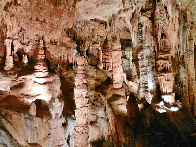
I will only subject you to a few photos from my arsenal.

The caverns were discovered in 1878 by a tinsmith and local photographer.
The tour lasts one hour and the caverns are mighty. Some of the ceilings are ten stories high. The next two photos give you an idea of the scale.


We love caves and I have lost count of how many we have visited. This was definitely the biggest and grandest but, somehow, the caves disappointed me. I prefer a certain amount of ruggedness and impoliteness in my caves. Here, all was paved and lighted and downright civilized. However, it was worth the visit and I would recommend you take the time too, if you are ever in that neck of the Shenandoah Valley.

This pool was filled with coins. We hear that people sometimes throw paper money in as well. Periodically, the money is collected and donated to charity. Almost a million dollars has been donated so far. Hard to wrap your mind around that figure, isn't it?


One of the things I dislike about caves is that I want to take a million photos because of all the awesomeness, but they rarely turn out to do the views justice. If I use a flash, it creates bright spots, and if I don't, the photos are blurry.
Like these reflecting pools, which were absolutely brilliant.


One of the young men had a strange-looking walking-stick thing, which was attached to his camera and steadied it while he took photos. I finally worked up the courage and asked him what it was.
Monopod.
I need one of these.
Children, take note. Your mother wants a monopod for Christmas.
It sounds like an alien intruder.

Some formations are translucent.


Everything is on a grand scale. No close-ups here.


 Right before you leave the caverns are the fried eggs.
I wanted to scrape these up and eat them, they are so adorable.


And a close-up of the adorableness.


We left Luray Caverns and drove south to Byoona Vista. 
But that's a story for another day.

Wednesday, October 16, 2013

Hangin' with Abe


On Sunday morning, we drove down to Gettysburg. We turned off the freeway on Hanover Road and passed some activity in this field. We stopped to have a gander and discovered that a live re-enactment was to take place later in the day, so we said thank-you-very-much-we-will-be-back and carried on our way.


We drove to the Visitor Center, which was overrun with hordes of Boy Scouts, so we checked out the Park Ranger tour information and left, deciding that we would return the next day. We walked around the town a little bit and then went back to the re-enactment. 
Jeff and this Confederate wannabe had a great political conversation, complaining about Obama and his minions. And I got to hear the other side of the Civil War debate. Which reminded me that things are rarely simple and that there are often valid points on both sides of an argument.


The re-enactment of the skirmish was kind of lame.
Can I say that?
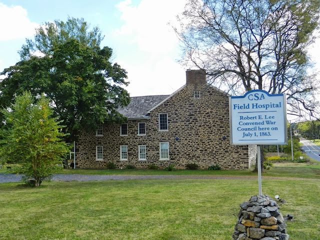
This was the site of a field hospital, so there were lots of very gory mannequins lying around, and piles of limbs and stuff.


And then they practised firing their muskets and everyone stood around and watched.


We decided to take the walking tour of the town.
We visited all 42 points of interest on the walking tour.
Yes, we did.

We said Hello to our friend, Mr. Lincoln.


And proceeded to walk.
And walk.
And walk.
Here are some photos of old houses, many of which stood during the battle of Gettysburg.


We learned about some of the individuals who lived in the town of Gettysburg at the time of the battle, such as Tillie Pierce, fifteen, who wrote an account of her experiences, and Jennie Wade, twenty years old, who was baking bread at her sister's house when she was hit by a bullet that penetrated two wooden doors before it killed her, making her the only confirmed civilian casualty of the battle.
Many of the houses and other buildings still bear the marks of battle.

Someone obviously has a sense of humour. 
Let's hope this sign at a closed gas station never becomes reality!


We stopped by the Gettysburg National Cemetery for a couple of ranger talks, because you know they are my favourite thing to do. The ranger gave an impassioned recital of the events leading up to Lincoln's speech at the cemetery, which was very enlightening for me, as I was fuzzy on the facts.
Imagine our surprise when the one soldier he told us about (to illustrate a typical soldier who died here) was an Osborne. No relation, that we know of. 


We went directly to a second talk across the parking lot, where we heard many more battle stories. We were even more surprised when one of the first people mentioned in the presentation was Thomas Osborne, Jeff's ancestor.
Cool.
I got very tired of battle stories and wandered around taking lots of photos, many of which illustrated the first post in this series, so I won't subject you to more.

We finished up the walking tour as it was getting dark, neatly avoiding solicitations to join a ghost tour. 
And I refused to talk about battlefields any more. 
Until tomorrow.