Sunday evening we spent some time perusing The Book and all of the various advertising magazines that we had picked up, planning the rest of our week. I should say, I perused and planned and Jeff nodded his head and grunted in agreement.
We knew that the first thing we wanted to do was see Waimea Canyon, as it had been suggested to us by several people. There are several possible hikes in the canyon, none of them easy and some requiring a 4WD vehicle, so our choice was easily narrowed down. The Pihea trail begins at the last lookout, Pu'u O Kila, and after two miles you can turn onto the Alaka'i Swamp Trail, which takes you through the highest swamp in the world. It is a most unique trail, unlike on other, so the choice was easy.
We got (what we thought was) an early start, first driving south to the entrance of the canyon, then twenty miles of canyon and views from the lookouts.

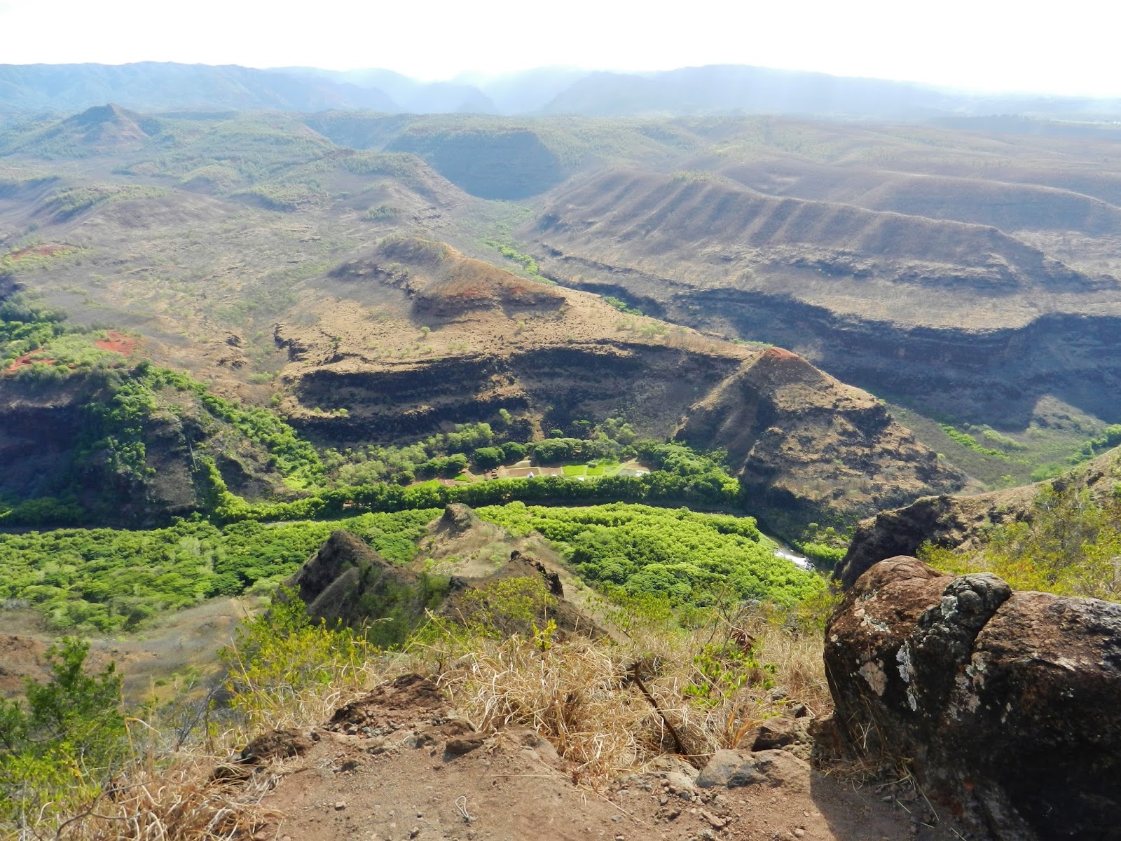
The canyon was formed of lava, cut through deeply by river and floods that were fed by the rains falling on Mount Wai'ale'ale, one of the wettest places on earth and almost always covered by clouds. The canyon is ten miles long, one mile wide, and 3,500 feet deep.


We were going to do a self-portrait, but, as happened several times, a kind stranger saved us from ourselves.


Don't feed the nenes!

We asked about the condition of the trail at the Koke'e Museum and were happy to hear that, even though it had rained all night, the trail wasn't very muddy. So we drove to the end of the road and girded up our loins.
I had taken two disassembled hiking poles with me on the plane. I was having trouble reassembling them and asked Jeff to help. He, of course, promptly broke one, but then I got it figured out so that at least I had a pole.
And I am the most important person in this twosome, so it worked out!
This is the view at the beginning of the hike.

I dare you to find the line where sea ends and sky begins.

The trail descended at first and was a bit slick. I began to get a sinking feeling in the pit of my stomach about this hike.


And up some more.

There was a lot of up and down on the first couple of miles. In this next photo, you can kind of see where the trail follows the top of the next ridge.


Every now and then, the trees would open up and we would be treated to views of the Kalalau Valley, and the breeze would blow softly and give us a little break from the heat.


Then the boardwalk began and life was a little easier. This boardwalk was built in the late 90's and is often in need of repair, but it beats slogging through the mud.


One of the many species of Hawaiian ginger. These bloomed along the trail and they scented the air rather nicely.


Things started to look a bit different after we turned off to the swamp. The trees got smaller and the air was cooler.

We had caught up with a friendly Californian named Henry, who seemed inclined to join us. It was nice to have someone new in the conversation. He had pink hair.
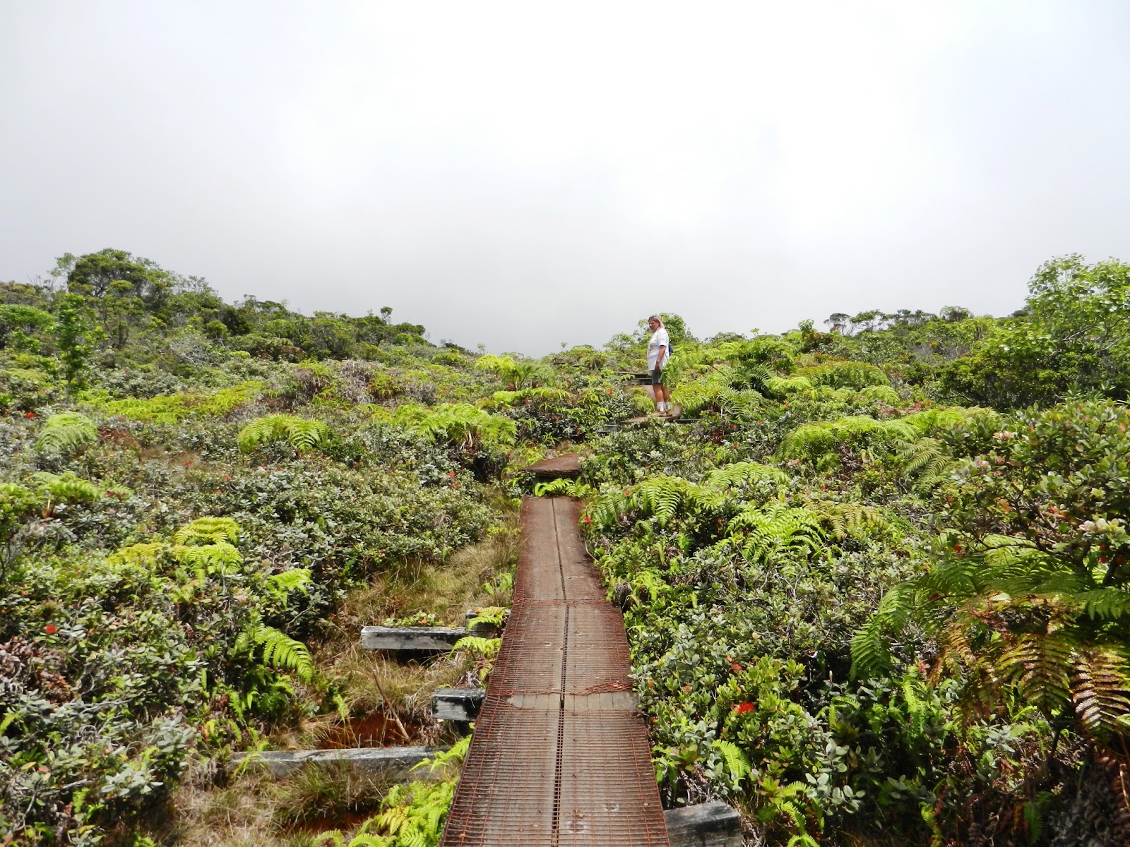
There are no tall trees in the swamp itself, just shrubs and grasses. The swamp is a 20 square mile plateau, sitting at 4,000 feet on top of impervious lava rock. It isn't a true swamp, but a very boggy tropical rain forest. Most of the water on Kaua'i comes from Alaka'i. When it rains, which it does almost every day, water overflows and seeps through cracks and fissures, creating waterfalls on the mountainsides. This may be why almost all of the island's streams and rivers are infected with the bacterium leptospirosis, which can cause some nasty diseases and even death. The water in the waterfalls looks so clean and pure, but you have to keep reminding yourself that it comes from The Bog!

The fog rolls in and out and it's a little spooky. I wouldn't want to hike this on my own.

Old power poles line the trail. They were built by the American government during the Second World War as an alternate power source in case the Japanese took Lihue.

We seemed to be hiking through the swamp forever, much longer than two miles.

Finally, we made it to the Kilohana Lookout, where, if you are very lucky, you will be treated to one of the best views in the world, looking all the way to the Napali Coast in the north.
Or so they say.

We were not. Which is okay, because we enjoyed many great views and persevered to the end of the swamp, so we felt very mighty.

We sat and rested our feet and ate power food for half an hour or so, while I chastised the fog. We shared our nuts and cranberries with Henry, who thought I was pretty hilarious.
And then we turned around and hiked back.


And then we went home to the geckos.
It was the second hardest hike of my life, eight miles of fairly grueling terrain, but I loved almost every minute of it. If you are interested in this hike, there is a good description of it here, with some other historical tidbits and a photo of the view we missed.
Casualty of the day: one hiking pole.
Hi Sue, I am really enjoying your memoirs of this trip. And VERY jealous (despite the heat, geckos, spiders and mossies)! Di
ReplyDeleteWow! That was an incredible hike. I don't think I would have survived it - hooray for you!
ReplyDelete